Formats a query result in OpenStreetMap XML. More...
Public Member Functions | |
| OSMFormatter () | |
| Constructor for this class. More... | |
| String[] | splitURL (String url) |
| void | addTagsFromJSONObject (JSONObject obj, XMLStreamWriter writer, String curfeatureid, String nameprefix) throws XMLStreamException |
| Adds tags from a GeoJSON object from which the KML result is created. More... | |
| String | formatter (ResultSet results, String startingElement, String featuretype, String propertytype, String typeColumn, Boolean onlyproperty, Boolean onlyhits, String srsName, String indvar, String epsg, List< String > eligiblenamespaces, List< String > noteligiblenamespaces, StyleObject mapstyle, Boolean alternativeFormat, Boolean invertXY, Boolean coverage, Writer out) throws XMLStreamException, JSONException, IOException |
| String | formatter (Model results, String startingElement, String featuretype, String propertytype, String typeColumn, Boolean onlyproperty, Boolean onlyhits, String srsName, String indvar, String epsg, List< String > eligiblenamespaces, List< String > noteligiblenamespaces, StyleObject mapstyle, Boolean alternativeFormat, Boolean invertXY, Boolean coverage, Writer out) throws XMLStreamException, IOException |
| Geometry | parseVectorLiteral (String literalValue, String literalType, String epsg, String srsName) |
| String | parseCoverageLiteral (String literalValue, String literalType, String epsg, String srsName) |
| Object | parseLiteral (String literalValue, String literalType, String epsg, String srsName) |
Static Public Member Functions | |
| static ResultFormatter | getFormatter (String formatString) |
Public Attributes | |
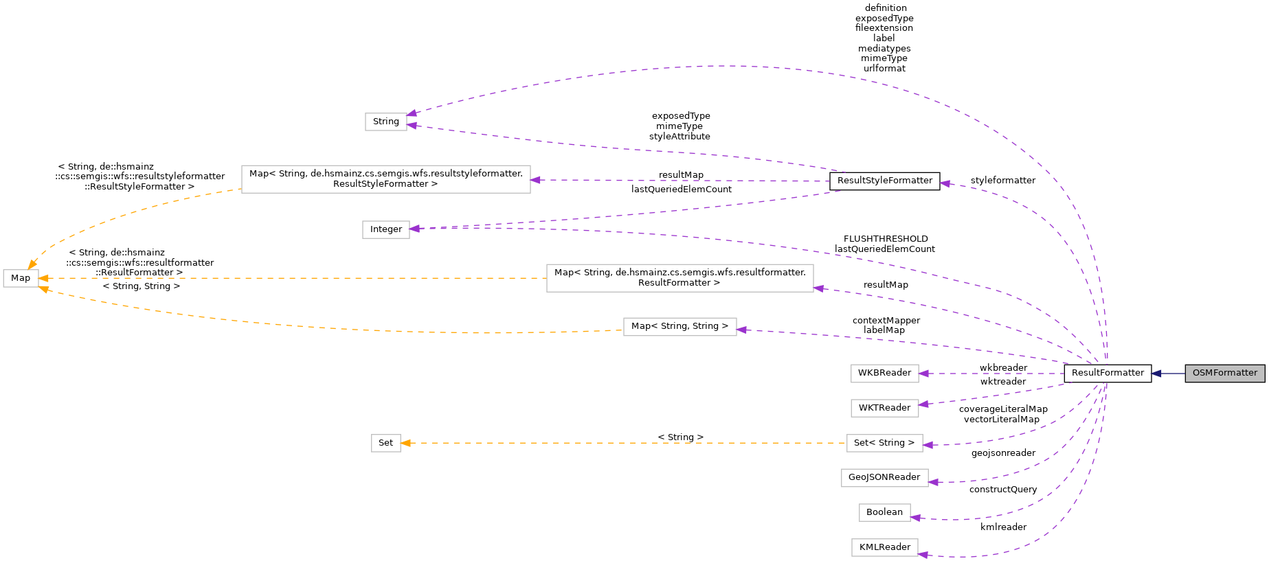
| Integer | lastQueriedElemCount =0 |
| String | mimeType ="text/plain" |
| String | exposedType ="application/vnd.geojson" |
| String | urlformat ="json" |
| String | label ="JSON" |
| String | definition ="" |
| String | fileextension ="json" |
| Boolean | constructQuery =false |
| Map< String, String > | contextMapper =new TreeMap<>() |
| ResultStyleFormatter | styleformatter |
| WKTReader | wktreader =new WKTReader() |
| WKBReader | wkbreader =new WKBReader() |
| KMLReader | kmlreader =new KMLReader() |
| GeoJSONReader | geojsonreader =new GeoJSONReader() |
Static Public Attributes | |
| static Map< String, ResultFormatter > | resultMap =new TreeMap<String, ResultFormatter>() |
| static Map< String, String > | labelMap =new TreeMap<>() |
| static Set< String > | vectorLiteralMap =new TreeSet<>() |
| static Set< String > | coverageLiteralMap =new TreeSet<>() |
| static final Integer | FLUSHTHRESHOLD =20 |
| static final String[] | mediatypes |
Static Package Functions | |
| static void | addToMaps (String key, ResultFormatter format) |
| [static initializer] | |
Detailed Description
Formats a query result in OpenStreetMap XML.
Constructor & Destructor Documentation
◆ OSMFormatter()
| OSMFormatter | ( | ) |
Constructor for this class.
References ResultFormatter.definition, ResultFormatter.exposedType, ResultFormatter.fileextension, ResultFormatter.label, ResultFormatter.mimeType, and ResultFormatter.urlformat.
Member Function Documentation
◆ [static initializer]()
|
staticpackageinherited |
◆ addTagsFromJSONObject()
| void addTagsFromJSONObject | ( | JSONObject | obj, |
| XMLStreamWriter | writer, | ||
| String | curfeatureid, | ||
| String | nameprefix | ||
| ) | throws XMLStreamException |
Adds tags from a GeoJSON object from which the KML result is created.
- Parameters
-
obj the JSONObject to process writer the XMLWriter to write out KML curfeatureid the current feature id to process nameprefix a nameprefix to store for recursive calls
- Exceptions
-
XMLStreamException if there was an error writing XML
Referenced by OSMFormatter.formatter().
◆ addToMaps()
|
staticpackageinherited |
References ResultFormatter.label, ResultFormatter.labelMap, ResultFormatter.mimeType, and ResultFormatter.resultMap.
◆ formatter() [1/2]
|
inherited |
Reimplemented in TTLFormatter, TrixFormatter, TrigFormatter, RDFThriftFormatter, RDFJSONFormatter, RDFFormatter, RDFEXIFormatter, NTFormatter, NQuadsFormatter, and N3Formatter.
Referenced by TripleStoreConnector.executeLDAPIQuery(), TripleStoreConnector.executePropertyValueQuery(), TripleStoreConnector.executeQuery(), CovJSONFormatter.formatter(), HTMLFormatter.formatter(), CypherFormatter.formatter(), GDFFormatter.formatter(), GEXFFormatter.formatter(), GraphMLFormatter.formatter(), GXLFormatter.formatter(), HDTFormatter.formatter(), N3Formatter.formatter(), NQuadsFormatter.formatter(), NTFormatter.formatter(), RDFEXIFormatter.formatter(), RDFFormatter.formatter(), RDFJSONFormatter.formatter(), RDFThriftFormatter.formatter(), TGFFormatter.formatter(), TrigFormatter.formatter(), TrixFormatter.formatter(), BSONFormatter.formatter(), GeoJSONLDFormatter.formatter(), GeoJSONSeqFormatter.formatter(), GMLFormatter.formatter(), GPXFormatter.formatter(), JSONPFormatter.formatter(), KMLFormatter.formatter(), MapMLFormatter.formatter(), MVTFormatter.formatter(), OSMFormatter.formatter(), YAMLFormatter.formatter(), and SVGFormatter.formatter().
◆ formatter() [2/2]
| String formatter | ( | ResultSet | results, |
| String | startingElement, | ||
| String | featuretype, | ||
| String | propertytype, | ||
| String | typeColumn, | ||
| Boolean | onlyproperty, | ||
| Boolean | onlyhits, | ||
| String | srsName, | ||
| String | indvar, | ||
| String | epsg, | ||
| List< String > | eligiblenamespaces, | ||
| List< String > | noteligiblenamespaces, | ||
| StyleObject | mapstyle, | ||
| Boolean | alternativeFormat, | ||
| Boolean | invertXY, | ||
| Boolean | coverage, | ||
| Writer | out | ||
| ) | throws XMLStreamException, JSONException, IOException |
Reimplemented from ResultFormatter.
References OSMFormatter.addTagsFromJSONObject(), ResultFormatter.FLUSHTHRESHOLD, ResultFormatter.formatter(), ResultFormatter.lastQueriedElemCount, WebService.nameSpaceCache, and ResultFormatter.resultMap.
◆ getFormatter()
|
staticinherited |
References ResultFormatter.resultMap.
Referenced by WebService.collectionInformation(), WebService.collectionItems(), WebService.collections(), WebService.docCollectionItemJSON(), WebService.docCollectionJSON(), TripleStoreConnector.executeLDAPIQuery(), TripleStoreConnector.executePropertyValueQuery(), TripleStoreConnector.executeQuery(), and WebService.queryables().
◆ parseCoverageLiteral()
|
inherited |
Reimplemented in VectorResultFormatter.
Referenced by CovJSONFormatter.formatter(), and ResultFormatter.parseLiteral().
◆ parseLiteral()
|
inherited |
References ResultFormatter.parseCoverageLiteral(), and ResultFormatter.parseVectorLiteral().
Referenced by RasterWKBFormatter.formatter(), XYZASCIIFormatter.formatter(), HexTuplesFormatter.formatter(), and TTLFormatter.formatter().
◆ parseVectorLiteral()
|
inherited |
References ReprojectionUtils.reproject().
Referenced by GeoJSONFormatter.formatJSONObject(), GeoJSONFormatter.formatJSONStreaming(), RasterWKBFormatter.formatter(), XYZASCIIFormatter.formatter(), HexTuplesFormatter.formatter(), TTLFormatter.formatter(), CSVFormatter.formatter(), EWKTFormatter.formatter(), GeoURIFormatter.formatter(), HexWKBFormatter.formatter(), LatLonTextFormatter.formatter(), ODSFormatter.formatter(), OpenLocationCodeFormatter.formatter(), OSMLinkFormatter.formatter(), PostgreSQLFormatter.formatter(), TWKBFormatter.formatter(), WKBFormatter.formatter(), WKTFormatter.formatter(), XLSFormatter.formatter(), XLSXFormatter.formatter(), and ResultFormatter.parseLiteral().
◆ splitURL()
| String [] splitURL | ( | String | url | ) |
Member Data Documentation
◆ constructQuery
|
inherited |
Referenced by CypherFormatter.CypherFormatter(), GDFFormatter.GDFFormatter(), GEXFFormatter.GEXFFormatter(), GraphMLFormatter.GraphMLFormatter(), GXLFormatter.GXLFormatter(), HDTFormatter.HDTFormatter(), HexTuplesFormatter.HexTuplesFormatter(), LDAPIJSONFormatter.LDAPIJSONFormatter(), N3Formatter.N3Formatter(), NQuadsFormatter.NQuadsFormatter(), NTFormatter.NTFormatter(), RDFEXIFormatter.RDFEXIFormatter(), RDFFormatter.RDFFormatter(), RDFJSONFormatter.RDFJSONFormatter(), RDFThriftFormatter.RDFThriftFormatter(), TGFFormatter.TGFFormatter(), TLPFormatter.TLPFormatter(), TrigFormatter.TrigFormatter(), TrixFormatter.TrixFormatter(), and TTLFormatter.TTLFormatter().
◆ contextMapper
|
inherited |
◆ coverageLiteralMap
|
staticinherited |
Referenced by HTMLFormatter.getVectorOrCoverageRepresentationForHTML().
◆ definition
|
inherited |
Referenced by ASCIIGridFormatter.ASCIIGridFormatter(), BSONFormatter.BSONFormatter(), WebService.collectionInformation(), CovJSONFormatter.CovJSONFormatter(), CSVFormatter.CSVFormatter(), CypherFormatter.CypherFormatter(), EWKTFormatter.EWKTFormatter(), GDFFormatter.GDFFormatter(), GeoHashFormatter.GeoHashFormatter(), GeoJSONFormatter.GeoJSONFormatter(), GeoJSONLDFormatter.GeoJSONLDFormatter(), GeoJSONSeqFormatter.GeoJSONSeqFormatter(), GeoRSSFormatter.GeoRSSFormatter(), GeoTIFFFormatter.GeoTIFFFormatter(), GeoURIFormatter.GeoURIFormatter(), GEXFFormatter.GEXFFormatter(), GMLFormatter.GMLFormatter(), GPXFormatter.GPXFormatter(), GraphMLFormatter.GraphMLFormatter(), GXLFormatter.GXLFormatter(), HDTFormatter.HDTFormatter(), HexTuplesFormatter.HexTuplesFormatter(), HexWKBFormatter.HexWKBFormatter(), HTMLFormatter.HTMLFormatter(), JSONLDFormatter.JSONLDFormatter(), JSONPFormatter.JSONPFormatter(), JSONSeqFormatter.JSONSeqFormatter(), KMLFormatter.KMLFormatter(), LDAPIJSONFormatter.LDAPIJSONFormatter(), MapMLFormatter.MapMLFormatter(), MVTFormatter.MVTFormatter(), N3Formatter.N3Formatter(), NQuadsFormatter.NQuadsFormatter(), NTFormatter.NTFormatter(), ODSFormatter.ODSFormatter(), OpenLocationCodeFormatter.OpenLocationCodeFormatter(), OSMFormatter.OSMFormatter(), PostgreSQLFormatter.PostgreSQLFormatter(), RDFEXIFormatter.RDFEXIFormatter(), RDFFormatter.RDFFormatter(), RDFJSONFormatter.RDFJSONFormatter(), RDFThriftFormatter.RDFThriftFormatter(), SVGFormatter.SVGFormatter(), TGFFormatter.TGFFormatter(), TLPFormatter.TLPFormatter(), TopoJSONFormatter.TopoJSONFormatter(), TrigFormatter.TrigFormatter(), TrixFormatter.TrixFormatter(), TTLFormatter.TTLFormatter(), TWKBFormatter.TWKBFormatter(), WKBFormatter.WKBFormatter(), WKTFormatter.WKTFormatter(), X3DFormatter.X3DFormatter(), XLSFormatter.XLSFormatter(), XLSXFormatter.XLSXFormatter(), XYZASCIIFormatter.XYZASCIIFormatter(), and YAMLFormatter.YAMLFormatter().
◆ exposedType
|
inherited |
Referenced by ASCIIGridFormatter.ASCIIGridFormatter(), BSONFormatter.BSONFormatter(), CovJSONFormatter.CovJSONFormatter(), CSVFormatter.CSVFormatter(), CypherFormatter.CypherFormatter(), EWKTFormatter.EWKTFormatter(), GDFFormatter.GDFFormatter(), GeoHashFormatter.GeoHashFormatter(), GeoJSONFormatter.GeoJSONFormatter(), GeoJSONLDFormatter.GeoJSONLDFormatter(), GeoJSONSeqFormatter.GeoJSONSeqFormatter(), GeoRSSFormatter.GeoRSSFormatter(), GeoTIFFFormatter.GeoTIFFFormatter(), GeoURIFormatter.GeoURIFormatter(), GEXFFormatter.GEXFFormatter(), GMLCOVFormatter.GMLCOVFormatter(), GMLFormatter.GMLFormatter(), GPXFormatter.GPXFormatter(), GraphMLFormatter.GraphMLFormatter(), GXFFormatter.GXFFormatter(), GXLFormatter.GXLFormatter(), HDTFormatter.HDTFormatter(), HexRasterWKBFormatter.HexRasterWKBFormatter(), HexTuplesFormatter.HexTuplesFormatter(), HexWKBFormatter.HexWKBFormatter(), HTMLFormatter.HTMLFormatter(), JSONFormatter.JSONFormatter(), JSONLDFormatter.JSONLDFormatter(), JSONPFormatter.JSONPFormatter(), JSONSeqFormatter.JSONSeqFormatter(), KMLFormatter.KMLFormatter(), LatLonTextFormatter.LatLonTextFormatter(), LDAPIJSONFormatter.LDAPIJSONFormatter(), MapMLFormatter.MapMLFormatter(), MVTFormatter.MVTFormatter(), N3Formatter.N3Formatter(), NQuadsFormatter.NQuadsFormatter(), NTFormatter.NTFormatter(), ODSFormatter.ODSFormatter(), OpenLocationCodeFormatter.OpenLocationCodeFormatter(), OSMFormatter.OSMFormatter(), OSMLinkFormatter.OSMLinkFormatter(), PolyshapeFormatter.PolyshapeFormatter(), PostgreSQLFormatter.PostgreSQLFormatter(), RasterWKBFormatter.RasterWKBFormatter(), RDFEXIFormatter.RDFEXIFormatter(), RDFFormatter.RDFFormatter(), RDFJSONFormatter.RDFJSONFormatter(), RDFThriftFormatter.RDFThriftFormatter(), SVGFormatter.SVGFormatter(), TGFFormatter.TGFFormatter(), TLPFormatter.TLPFormatter(), TopoJSONFormatter.TopoJSONFormatter(), TrigFormatter.TrigFormatter(), TrixFormatter.TrixFormatter(), TTLFormatter.TTLFormatter(), TWKBFormatter.TWKBFormatter(), WKBFormatter.WKBFormatter(), WKTFormatter.WKTFormatter(), X3DFormatter.X3DFormatter(), XLSFormatter.XLSFormatter(), XLSXFormatter.XLSXFormatter(), XYZASCIIFormatter.XYZASCIIFormatter(), and YAMLFormatter.YAMLFormatter().
◆ fileextension
|
inherited |
Referenced by ASCIIGridFormatter.ASCIIGridFormatter(), BSONFormatter.BSONFormatter(), WebService.collectionItems(), CovJSONFormatter.CovJSONFormatter(), CSVFormatter.CSVFormatter(), CypherFormatter.CypherFormatter(), WebService.docCollectionItemJSON(), WebService.docCollectionJSON(), EWKTFormatter.EWKTFormatter(), GDFFormatter.GDFFormatter(), GeoHashFormatter.GeoHashFormatter(), GeoJSONFormatter.GeoJSONFormatter(), GeoJSONLDFormatter.GeoJSONLDFormatter(), GeoJSONSeqFormatter.GeoJSONSeqFormatter(), GeoRSSFormatter.GeoRSSFormatter(), GeoTIFFFormatter.GeoTIFFFormatter(), GeoURIFormatter.GeoURIFormatter(), GEXFFormatter.GEXFFormatter(), GMLCOVFormatter.GMLCOVFormatter(), GMLFormatter.GMLFormatter(), GPXFormatter.GPXFormatter(), GraphMLFormatter.GraphMLFormatter(), GXFFormatter.GXFFormatter(), GXLFormatter.GXLFormatter(), HDTFormatter.HDTFormatter(), HexRasterWKBFormatter.HexRasterWKBFormatter(), HexTuplesFormatter.HexTuplesFormatter(), HexWKBFormatter.HexWKBFormatter(), HTMLFormatter.HTMLFormatter(), JSONFormatter.JSONFormatter(), JSONLDFormatter.JSONLDFormatter(), JSONPFormatter.JSONPFormatter(), JSONSeqFormatter.JSONSeqFormatter(), KMLFormatter.KMLFormatter(), LatLonTextFormatter.LatLonTextFormatter(), LDAPIJSONFormatter.LDAPIJSONFormatter(), MapMLFormatter.MapMLFormatter(), MVTFormatter.MVTFormatter(), N3Formatter.N3Formatter(), NQuadsFormatter.NQuadsFormatter(), NTFormatter.NTFormatter(), ODSFormatter.ODSFormatter(), OpenLocationCodeFormatter.OpenLocationCodeFormatter(), OSMFormatter.OSMFormatter(), OSMLinkFormatter.OSMLinkFormatter(), PolyshapeFormatter.PolyshapeFormatter(), PostgreSQLFormatter.PostgreSQLFormatter(), RasterWKBFormatter.RasterWKBFormatter(), RDFEXIFormatter.RDFEXIFormatter(), RDFFormatter.RDFFormatter(), RDFJSONFormatter.RDFJSONFormatter(), RDFThriftFormatter.RDFThriftFormatter(), SVGFormatter.SVGFormatter(), TGFFormatter.TGFFormatter(), TLPFormatter.TLPFormatter(), TopoJSONFormatter.TopoJSONFormatter(), TrigFormatter.TrigFormatter(), TrixFormatter.TrixFormatter(), TTLFormatter.TTLFormatter(), TWKBFormatter.TWKBFormatter(), WKBFormatter.WKBFormatter(), WKTFormatter.WKTFormatter(), X3DFormatter.X3DFormatter(), XLSFormatter.XLSFormatter(), XLSXFormatter.XLSXFormatter(), XYZASCIIFormatter.XYZASCIIFormatter(), and YAMLFormatter.YAMLFormatter().
◆ FLUSHTHRESHOLD
|
staticinherited |
Referenced by XYZASCIIFormatter.formatter(), EWKTFormatter.formatter(), GeoURIFormatter.formatter(), GMLFormatter.formatter(), GPXFormatter.formatter(), HexWKBFormatter.formatter(), JSONSeqFormatter.formatter(), KMLFormatter.formatter(), LatLonTextFormatter.formatter(), MapMLFormatter.formatter(), OpenLocationCodeFormatter.formatter(), OSMFormatter.formatter(), OSMLinkFormatter.formatter(), PostgreSQLFormatter.formatter(), TWKBFormatter.formatter(), WKBFormatter.formatter(), WKTFormatter.formatter(), and SVGFormatter.formatter().
◆ geojsonreader
|
inherited |
Referenced by CovJSONFormatter.createObservableParametersAndRanges().
◆ kmlreader
|
inherited |
◆ label
|
inherited |
Referenced by ResultFormatter.addToMaps(), ASCIIGridFormatter.ASCIIGridFormatter(), BSONFormatter.BSONFormatter(), HTMLFormatter.collectColumns(), CovJSONFormatter.CovJSONFormatter(), CSVFormatter.CSVFormatter(), CypherFormatter.CypherFormatter(), EWKTFormatter.EWKTFormatter(), GDFFormatter.GDFFormatter(), GeoHashFormatter.GeoHashFormatter(), GeoJSONFormatter.GeoJSONFormatter(), GeoJSONLDFormatter.GeoJSONLDFormatter(), GeoJSONSeqFormatter.GeoJSONSeqFormatter(), GeoRSSFormatter.GeoRSSFormatter(), GeoTIFFFormatter.GeoTIFFFormatter(), GeoURIFormatter.GeoURIFormatter(), GEXFFormatter.GEXFFormatter(), GMLCOVFormatter.GMLCOVFormatter(), GMLFormatter.GMLFormatter(), GPXFormatter.GPXFormatter(), GraphMLFormatter.GraphMLFormatter(), GXFFormatter.GXFFormatter(), GXLFormatter.GXLFormatter(), HDTFormatter.HDTFormatter(), HexRasterWKBFormatter.HexRasterWKBFormatter(), HexTuplesFormatter.HexTuplesFormatter(), HexWKBFormatter.HexWKBFormatter(), HTMLFormatter.HTMLFormatter(), JSONFormatter.JSONFormatter(), JSONLDFormatter.JSONLDFormatter(), JSONPFormatter.JSONPFormatter(), JSONSeqFormatter.JSONSeqFormatter(), KMLFormatter.KMLFormatter(), LatLonTextFormatter.LatLonTextFormatter(), LDAPIJSONFormatter.LDAPIJSONFormatter(), MapMLFormatter.MapMLFormatter(), MVTFormatter.MVTFormatter(), N3Formatter.N3Formatter(), NQuadsFormatter.NQuadsFormatter(), NTFormatter.NTFormatter(), ODSFormatter.ODSFormatter(), OpenLocationCodeFormatter.OpenLocationCodeFormatter(), OSMFormatter.OSMFormatter(), OSMLinkFormatter.OSMLinkFormatter(), PolyshapeFormatter.PolyshapeFormatter(), PostgreSQLFormatter.PostgreSQLFormatter(), RasterWKBFormatter.RasterWKBFormatter(), RDFEXIFormatter.RDFEXIFormatter(), RDFFormatter.RDFFormatter(), RDFJSONFormatter.RDFJSONFormatter(), RDFThriftFormatter.RDFThriftFormatter(), SVGFormatter.SVGFormatter(), TGFFormatter.TGFFormatter(), TLPFormatter.TLPFormatter(), TopoJSONFormatter.TopoJSONFormatter(), TrigFormatter.TrigFormatter(), TrixFormatter.TrixFormatter(), TTLFormatter.TTLFormatter(), TWKBFormatter.TWKBFormatter(), WKBFormatter.WKBFormatter(), WKTFormatter.WKTFormatter(), X3DFormatter.X3DFormatter(), XLSFormatter.XLSFormatter(), XLSXFormatter.XLSXFormatter(), XYZASCIIFormatter.XYZASCIIFormatter(), and YAMLFormatter.YAMLFormatter().
◆ labelMap
|
staticinherited |
Referenced by ResultFormatter.addToMaps(), and WebService.collectionInformation().
◆ lastQueriedElemCount
|
inherited |
Referenced by TripleStoreConnector.executePropertyValueQuery(), TripleStoreConnector.executeQuery(), GeoJSONFormatter.formatJSONObject(), GeoJSONFormatter.formatJSONStreaming(), GeoHashFormatter.formatter(), CovJSONFormatter.formatter(), RasterWKBFormatter.formatter(), XYZASCIIFormatter.formatter(), HTMLFormatter.formatter(), CypherFormatter.formatter(), GDFFormatter.formatter(), GEXFFormatter.formatter(), GraphMLFormatter.formatter(), GXLFormatter.formatter(), HDTFormatter.formatter(), HexTuplesFormatter.formatter(), LDAPIJSONFormatter.formatter(), N3Formatter.formatter(), NQuadsFormatter.formatter(), NTFormatter.formatter(), RDFEXIFormatter.formatter(), RDFFormatter.formatter(), RDFJSONFormatter.formatter(), RDFThriftFormatter.formatter(), TGFFormatter.formatter(), TrigFormatter.formatter(), TrixFormatter.formatter(), TTLFormatter.formatter(), BSONFormatter.formatter(), CSVFormatter.formatter(), EWKTFormatter.formatter(), GeoJSONLDFormatter.formatter(), GeoJSONSeqFormatter.formatter(), GeoURIFormatter.formatter(), GMLFormatter.formatter(), GPXFormatter.formatter(), HexWKBFormatter.formatter(), JSONFormatter.formatter(), JSONLDFormatter.formatter(), JSONPFormatter.formatter(), JSONSeqFormatter.formatter(), KMLFormatter.formatter(), LatLonTextFormatter.formatter(), MapMLFormatter.formatter(), MVTFormatter.formatter(), ODSFormatter.formatter(), OpenLocationCodeFormatter.formatter(), OSMFormatter.formatter(), OSMLinkFormatter.formatter(), PostgreSQLFormatter.formatter(), TWKBFormatter.formatter(), WKBFormatter.formatter(), WKTFormatter.formatter(), XLSFormatter.formatter(), XLSXFormatter.formatter(), YAMLFormatter.formatter(), and SVGFormatter.formatter().
◆ mediatypes
|
staticinherited |
◆ mimeType
|
inherited |
Referenced by ResultFormatter.addToMaps(), ASCIIGridFormatter.ASCIIGridFormatter(), BSONFormatter.BSONFormatter(), WebService.collectionItems(), WebService.collections(), CovJSONFormatter.CovJSONFormatter(), CSVFormatter.CSVFormatter(), CypherFormatter.CypherFormatter(), WebService.docCollectionItemJSON(), WebService.docCollectionJSON(), EWKTFormatter.EWKTFormatter(), GDFFormatter.GDFFormatter(), GeoHashFormatter.GeoHashFormatter(), GeoJSONFormatter.GeoJSONFormatter(), GeoJSONLDFormatter.GeoJSONLDFormatter(), GeoJSONSeqFormatter.GeoJSONSeqFormatter(), GeoRSSFormatter.GeoRSSFormatter(), GeoTIFFFormatter.GeoTIFFFormatter(), GeoURIFormatter.GeoURIFormatter(), GEXFFormatter.GEXFFormatter(), GMLCOVFormatter.GMLCOVFormatter(), GMLFormatter.GMLFormatter(), GPXFormatter.GPXFormatter(), GraphMLFormatter.GraphMLFormatter(), GXFFormatter.GXFFormatter(), GXLFormatter.GXLFormatter(), HDTFormatter.HDTFormatter(), HexRasterWKBFormatter.HexRasterWKBFormatter(), HexTuplesFormatter.HexTuplesFormatter(), HexWKBFormatter.HexWKBFormatter(), HTMLFormatter.HTMLFormatter(), JSONFormatter.JSONFormatter(), JSONLDFormatter.JSONLDFormatter(), JSONPFormatter.JSONPFormatter(), JSONSeqFormatter.JSONSeqFormatter(), KMLFormatter.KMLFormatter(), LatLonTextFormatter.LatLonTextFormatter(), LDAPIJSONFormatter.LDAPIJSONFormatter(), MapMLFormatter.MapMLFormatter(), MVTFormatter.MVTFormatter(), N3Formatter.N3Formatter(), NQuadsFormatter.NQuadsFormatter(), NTFormatter.NTFormatter(), ODSFormatter.ODSFormatter(), OpenLocationCodeFormatter.OpenLocationCodeFormatter(), OSMFormatter.OSMFormatter(), OSMLinkFormatter.OSMLinkFormatter(), PolyshapeFormatter.PolyshapeFormatter(), PostgreSQLFormatter.PostgreSQLFormatter(), RasterWKBFormatter.RasterWKBFormatter(), RDFEXIFormatter.RDFEXIFormatter(), RDFFormatter.RDFFormatter(), RDFJSONFormatter.RDFJSONFormatter(), RDFThriftFormatter.RDFThriftFormatter(), SVGFormatter.SVGFormatter(), TGFFormatter.TGFFormatter(), TLPFormatter.TLPFormatter(), TopoJSONFormatter.TopoJSONFormatter(), TrigFormatter.TrigFormatter(), TrixFormatter.TrixFormatter(), TTLFormatter.TTLFormatter(), TWKBFormatter.TWKBFormatter(), WKBFormatter.WKBFormatter(), WKTFormatter.WKTFormatter(), X3DFormatter.X3DFormatter(), XLSFormatter.XLSFormatter(), XLSXFormatter.XLSXFormatter(), XYZASCIIFormatter.XYZASCIIFormatter(), and YAMLFormatter.YAMLFormatter().
◆ resultMap
|
staticinherited |
Referenced by ResultFormatter.addToMaps(), WebService.collectionInformation(), WebService.collectionItems(), WebService.collections(), WebService.constructCapabilitiesWFS10(), WebService.describeFeatureType(), WebService.describeFeatureTypeWFS10(), CovJSONFormatter.formatter(), HTMLFormatter.formatter(), CypherFormatter.formatter(), GDFFormatter.formatter(), GEXFFormatter.formatter(), GraphMLFormatter.formatter(), GXLFormatter.formatter(), HDTFormatter.formatter(), N3Formatter.formatter(), NQuadsFormatter.formatter(), NTFormatter.formatter(), RDFEXIFormatter.formatter(), RDFFormatter.formatter(), RDFJSONFormatter.formatter(), RDFThriftFormatter.formatter(), TGFFormatter.formatter(), TrigFormatter.formatter(), TrixFormatter.formatter(), BSONFormatter.formatter(), GeoJSONLDFormatter.formatter(), GeoJSONSeqFormatter.formatter(), GMLFormatter.formatter(), GPXFormatter.formatter(), JSONPFormatter.formatter(), KMLFormatter.formatter(), MapMLFormatter.formatter(), MVTFormatter.formatter(), OSMFormatter.formatter(), YAMLFormatter.formatter(), SVGFormatter.formatter(), WebService.getFeatureById(), ResultFormatter.getFormatter(), and WebService.landingPage().
◆ styleformatter
|
inherited |
◆ urlformat
|
inherited |
Referenced by ASCIIGridFormatter.ASCIIGridFormatter(), BSONFormatter.BSONFormatter(), WebService.collectionInformation(), CovJSONFormatter.CovJSONFormatter(), CSVFormatter.CSVFormatter(), CypherFormatter.CypherFormatter(), EWKTFormatter.EWKTFormatter(), GDFFormatter.GDFFormatter(), GeoHashFormatter.GeoHashFormatter(), GeoJSONFormatter.GeoJSONFormatter(), GeoJSONLDFormatter.GeoJSONLDFormatter(), GeoJSONSeqFormatter.GeoJSONSeqFormatter(), GeoRSSFormatter.GeoRSSFormatter(), GeoTIFFFormatter.GeoTIFFFormatter(), GeoURIFormatter.GeoURIFormatter(), GEXFFormatter.GEXFFormatter(), GMLCOVFormatter.GMLCOVFormatter(), GMLFormatter.GMLFormatter(), GPXFormatter.GPXFormatter(), GraphMLFormatter.GraphMLFormatter(), GXFFormatter.GXFFormatter(), GXLFormatter.GXLFormatter(), HDTFormatter.HDTFormatter(), HexRasterWKBFormatter.HexRasterWKBFormatter(), HexTuplesFormatter.HexTuplesFormatter(), HexWKBFormatter.HexWKBFormatter(), HTMLFormatter.HTMLFormatter(), JSONFormatter.JSONFormatter(), JSONLDFormatter.JSONLDFormatter(), JSONPFormatter.JSONPFormatter(), JSONSeqFormatter.JSONSeqFormatter(), KMLFormatter.KMLFormatter(), LatLonTextFormatter.LatLonTextFormatter(), LDAPIJSONFormatter.LDAPIJSONFormatter(), MapMLFormatter.MapMLFormatter(), MVTFormatter.MVTFormatter(), N3Formatter.N3Formatter(), NQuadsFormatter.NQuadsFormatter(), NTFormatter.NTFormatter(), ODSFormatter.ODSFormatter(), OpenLocationCodeFormatter.OpenLocationCodeFormatter(), OSMFormatter.OSMFormatter(), OSMLinkFormatter.OSMLinkFormatter(), PolyshapeFormatter.PolyshapeFormatter(), PostgreSQLFormatter.PostgreSQLFormatter(), RasterWKBFormatter.RasterWKBFormatter(), RDFEXIFormatter.RDFEXIFormatter(), RDFFormatter.RDFFormatter(), RDFJSONFormatter.RDFJSONFormatter(), RDFThriftFormatter.RDFThriftFormatter(), SVGFormatter.SVGFormatter(), TGFFormatter.TGFFormatter(), TLPFormatter.TLPFormatter(), TopoJSONFormatter.TopoJSONFormatter(), TrigFormatter.TrigFormatter(), TrixFormatter.TrixFormatter(), TTLFormatter.TTLFormatter(), TWKBFormatter.TWKBFormatter(), WKBFormatter.WKBFormatter(), WKTFormatter.WKTFormatter(), X3DFormatter.X3DFormatter(), XLSFormatter.XLSFormatter(), XLSXFormatter.XLSXFormatter(), XYZASCIIFormatter.XYZASCIIFormatter(), and YAMLFormatter.YAMLFormatter().
◆ vectorLiteralMap
|
staticinherited |
Referenced by HTMLFormatter.getVectorOrCoverageRepresentationForHTML().
◆ wkbreader
|
inherited |
◆ wktreader
|
inherited |
