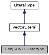
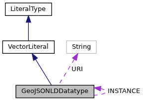
WKTDatatype class allows the URI "geo:wktLiteral" to be used as a datatype and it will parse that datatype to a JTS Geometry. More...


Public Member Functions | |
| String | unparse (Geometry geometry) |
| This method Un-parses the JTS Geometry to the WKT literal. More... | |
| Geometry | read (String geometryLiteral) |
| String | toString () |
Static Public Attributes | |
| static final String | URI = POSTGIS.GeoJSONLD |
| The default WKT type URI. More... | |
| static final GeoJSONLDDatatype | INSTANCE = new GeoJSONLDDatatype() |
| A static instance of WKTDatatype. More... | |
Detailed Description
WKTDatatype class allows the URI "geo:wktLiteral" to be used as a datatype and it will parse that datatype to a JTS Geometry.
Req 10 All RDFS Literals of type geo:wktLiteral shall consist of an optional URI identifying the coordinate reference system followed by Simple Features Well Known Text (WKT) describing a geometric value. Valid geo:wktLiterals are formed by concatenating a valid, absolute URI as defined in [RFC 2396], one or more spaces (Unicode U+0020 character) as a separator, and a WKT string as defined in Simple Features [ISO 19125-1].
Req 11 The URI
shall be assumed as the spatial reference system for geo:wktLiterals that do not * specify an explicit spatial reference system URI.
Member Function Documentation
◆ read()
| Geometry read | ( | String | geometryLiteral | ) |
Reimplemented from VectorLiteral.
◆ toString()
| String toString | ( | ) |
References GeoJSONLDDatatype.URI.
◆ unparse()
| String unparse | ( | Geometry | geometry | ) |
This method Un-parses the JTS Geometry to the WKT literal.
- Parameters
-
geometry - the JTS Geometry to be un-parsed
- Returns
- WKT - the returned WKT Literal.
Notice that the Spatial Reference System is not specified in returned WKT literal.
Reimplemented from VectorLiteral.
Member Data Documentation
◆ INSTANCE
|
static |
A static instance of WKTDatatype.
◆ URI
|
static |
The default WKT type URI.
Referenced by GeoJSONLDDatatype.toString().
