RasterToWorldCoordY Class Reference
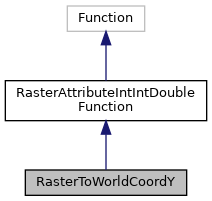
Inheritance diagram for RasterToWorldCoordY:

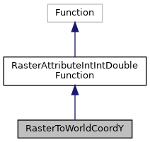
Collaboration diagram for RasterToWorldCoordY:

Public Member Functions | |
| String | getURI () |
| Double | attribute (GridCoverage raster, Integer longitude, Integer latitude) |
| Value | evaluate (ValueFactory valueFactory, Value... args) throws ValueExprEvaluationException |
Member Function Documentation
◆ attribute()
| Double attribute | ( | GridCoverage | raster, |
| Integer | longitude, | ||
| Integer | latitude | ||
| ) |
Reimplemented from RasterAttributeIntIntDoubleFunction.
◆ evaluate()
|
inherited |
19 throw new ValueExprEvaluationException(getURI() + " requires exactly 1 arguments, got " + args.length);
abstract Double attribute(GridCoverage geom, Integer longitude, Integer latitude)
References RasterAttributeIntIntDoubleFunction.attribute(), and LiteralRegistry.getLiteral().
Referenced by RasterToWorldCoordXTest.testRasterToWorldCoordX(), RasterToWorldCoordYTest.testRasterToWorldCoordY(), WorldToRasterCoordXTest.testWorldToRasterCoordX(), and WorldToRasterCoordYTest.testWorldToRasterCoordY().
◆ getURI()
| String getURI | ( | ) |
References POSTGIS.st_rasterToWorldCoordY.
