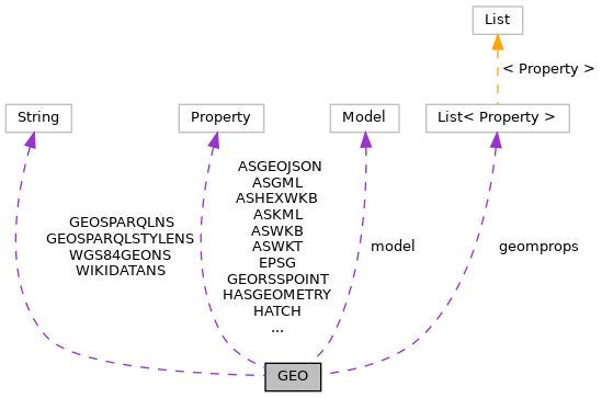
Static Public Attributes | |
| static final String | WGS84GEONS = "http://www.w3.org/2003/01/geo/wgs84_pos#" |
| static final String | GEOSPARQLNS = "http://www.opengis.net/ont/geosparql#" |
| static final String | GEOSPARQLSTYLENS = "http://www.opengis.net/ont/geosparql/style#" |
| static final String | WIKIDATANS = "http://www.wikidata.org/prop/direct/" |
| static final Property | P_LONG = model.createProperty( WGS84GEONS + "long" ) |
| static final Property | P_LAT = model.createProperty( WGS84GEONS + "lat" ) |
| static final Property | P_GEOMETRY = model.createProperty( WGS84GEONS + "geometry" ) |
| static final Property | LOCATION = model.createProperty( WGS84GEONS + "location" ) |
| static final Property | HASGEOMETRY = model.createProperty( GEOSPARQLNS + "hasGeometry" ) |
| static final Property | ASWKT = model.createProperty( GEOSPARQLNS + "asWKT" ) |
| static final Property | ASHEXWKB = model.createProperty( GEOSPARQLNS + "asHexWKB" ) |
| static final Property | ASWKB = model.createProperty( GEOSPARQLNS + "asWKB" ) |
| static final Property | ASGEOJSON = model.createProperty( GEOSPARQLNS + "asGeoJSON" ) |
| static final Property | ASGML = model.createProperty( GEOSPARQLNS + "asGML" ) |
| static final Property | EPSG = model.createProperty( GEOSPARQLNS + "epsg" ) |
| static final Property | STYLE = model.createProperty( GEOSPARQLNS + "style" ) |
| static final Property | LINESTRINGSTYLE =model.createProperty(GEOSPARQLNS+"lineStringStyle") |
| static final Property | LINESTRINGIMAGE =model.createProperty(GEOSPARQLNS+"lineStringImage") |
| static final Property | POINTSTYLE =model.createProperty(GEOSPARQLNS+"pointStyle") |
| static final Property | POINTIMAGE =model.createProperty(GEOSPARQLNS+"pointImage") |
| static final Property | POLYGONSTYLE =model.createProperty(GEOSPARQLNS+"polygonStyle") |
| static final Property | POLYGONIMAGE =model.createProperty(GEOSPARQLNS+"polygonImage") |
| static final Property | HATCH =model.createProperty(GEOSPARQLNS+"hatch") |
| static final Property | LINESTRINGIMAGESTYLE =model.createProperty(GEOSPARQLNS+"lineStringImageStyle") |
| static final Property | POPUPSTYLE = model.createProperty( GEOSPARQLNS + "popupStyle" ) |
| static final Property | TEXTSTYLE = model.createProperty( GEOSPARQLNS + "textStyle" ) |
| static final Property | LINESTRINGSTYLE2 =model.createProperty(GEOSPARQLSTYLENS+"lineStringStyle") |
| static final Property | LINESTRINGIMAGE2 =model.createProperty(GEOSPARQLSTYLENS+"lineStringImage") |
| static final Property | POINTSTYLE2 =model.createProperty(GEOSPARQLSTYLENS+"pointStyle") |
| static final Property | POINTIMAGE2 =model.createProperty(GEOSPARQLSTYLENS+"pointImage") |
| static final Property | POLYGONSTYLE2 =model.createProperty(GEOSPARQLSTYLENS+"polygonStyle") |
| static final Property | POLYGONIMAGE2 =model.createProperty(GEOSPARQLSTYLENS+"polygonImage") |
| static final Property | HATCH2 =model.createProperty(GEOSPARQLSTYLENS+"hatch") |
| static final Property | LINESTRINGIMAGESTYLE2 =model.createProperty(GEOSPARQLSTYLENS+"lineStringImageStyle") |
| static final Property | POPUPSTYLE2 = model.createProperty( GEOSPARQLSTYLENS + "popupStyle" ) |
| static final Property | TEXTSTYLE2 = model.createProperty( GEOSPARQLSTYLENS + "textStyle" ) |
| static final Property | P625 = model.createProperty( WIKIDATANS + "P625" ) |
| static final Property | GEORSSPOINT = model.createProperty("http://www.georss.org/georss/point") |
| static final Property | ASKML = model.createProperty( GEOSPARQLNS + "asKML" ) |
| static List< Property > | geomprops =Arrays.asList(new Property[] {P_LONG,P_LAT,P_GEOMETRY,LOCATION,HASGEOMETRY,ASWKT,ASKML,ASGML,ASWKB,ASHEXWKB,ASGEOJSON,P625,GEORSSPOINT}) |
Static Private Attributes | |
| static Model | model = ModelFactory.createDefaultModel() |
Member Data Documentation
◆ ASGEOJSON
|
static |
Referenced by ResourceDescription.addAllGeoms(), GeoModelWriter.handleGeometry(), and LDWriter.write().
◆ ASGML
|
static |
Referenced by GeoModelWriter.handleGeometry().
◆ ASHEXWKB
|
static |
Referenced by GeoModelWriter.handleGeometry().
◆ ASKML
|
static |
Referenced by GeoModelWriter.handleGeometry().
◆ ASWKB
|
static |
Referenced by GeoModelWriter.handleGeometry().
◆ ASWKT
|
static |
◆ EPSG
|
static |
Referenced by Configuration.Configuration(), ResourceDescription.getEPSG(), GeoModelWriter.handleGeometry(), AbstractGeoJSONWriter.prepareGeoJSONString(), X3DWriter.write(), XYZASCIIWriter.write(), ESRIJSONWriter.write(), EWKTWriter.write(), GeoHashWriter.write(), GeoURIWriter.write(), GMLWriter.write(), GoogleMapsLinkWriter.write(), GPXWriter.write(), KMLWriter.write(), LatLonTextWriter.write(), MapMLWriter.write(), OpenLocationCodeWriter.write(), OSMLinkWriter.write(), OSMWriter.write(), SVGWriter.write(), TopoJSONWriter.write(), TWKBWriterr.write(), WKBWriterr.write(), WKTWriter.write(), XLSWriter.write(), XLSXWriter.write(), and LDWriter.write().
◆ geomprops
|
static |
◆ GEORSSPOINT
|
static |
Referenced by GeoModelWriter.handleGeometry(), ModelWriter.write(), and LDWriter.write().
◆ GEOSPARQLNS
|
static |
◆ GEOSPARQLSTYLENS
|
static |
◆ HASGEOMETRY
|
static |
Referenced by ResourceDescription.addAllGeoms(), Configuration.Configuration(), and ModelWriter.write().
◆ HATCH
|
static |
Referenced by GeoModelWriter.handleStyle().
◆ HATCH2
|
static |
Referenced by GeoModelWriter.handleStyle().
◆ LINESTRINGIMAGE
|
static |
Referenced by GeoModelWriter.handleStyle().
◆ LINESTRINGIMAGE2
|
static |
Referenced by GeoModelWriter.handleStyle().
◆ LINESTRINGIMAGESTYLE
|
static |
Referenced by GeoModelWriter.handleStyle().
◆ LINESTRINGIMAGESTYLE2
|
static |
Referenced by GeoModelWriter.handleStyle().
◆ LINESTRINGSTYLE
|
static |
Referenced by GeoModelWriter.handleStyle().
◆ LINESTRINGSTYLE2
|
static |
Referenced by GeoModelWriter.handleStyle().
◆ LOCATION
|
static |
Referenced by ResourceDescription.addAllGeoms().
◆ model
|
staticprivate |
◆ P625
|
static |
Referenced by GeoModelWriter.handleGeometry(), ModelWriter.write(), and LDWriter.write().
◆ P_GEOMETRY
|
static |
Referenced by ResourceDescription.addAllGeoms(), GeoModelWriter.handleGeometry(), and LDWriter.write().
◆ P_LAT
|
static |
Referenced by ResourceDescription.addPoint(), GeoModelWriter.handleGeometry(), ModelWriter.write(), and LDWriter.write().
◆ P_LONG
|
static |
Referenced by ResourceDescription.addPoint(), GeoModelWriter.handleGeometry(), and LDWriter.write().
◆ POINTIMAGE
|
static |
Referenced by GeoModelWriter.handleStyle().
◆ POINTIMAGE2
|
static |
Referenced by GeoModelWriter.handleStyle().
◆ POINTSTYLE
|
static |
Referenced by GeoModelWriter.handleStyle().
◆ POINTSTYLE2
|
static |
Referenced by GeoModelWriter.handleStyle().
◆ POLYGONIMAGE
|
static |
Referenced by GeoModelWriter.handleStyle().
◆ POLYGONIMAGE2
|
static |
Referenced by GeoModelWriter.handleStyle().
◆ POLYGONSTYLE
|
static |
Referenced by GeoModelWriter.handleStyle().
◆ POLYGONSTYLE2
|
static |
Referenced by GeoModelWriter.handleStyle().
◆ POPUPSTYLE
|
static |
Referenced by GeoModelWriter.handleStyle().
◆ POPUPSTYLE2
|
static |
Referenced by GeoModelWriter.handleStyle().
◆ STYLE
|
static |
Referenced by ResourceDescription.getStyle(), AbstractGeoJSONWriter.prepareGeoJSONString(), and KMLWriter.write().
◆ TEXTSTYLE
|
static |
◆ TEXTSTYLE2
|
static |
Referenced by GeoModelWriter.handleStyle().
◆ WGS84GEONS
|
static |
◆ WIKIDATANS
|
static |
